
Chapter 4: Metapopulations and Landscape Ecology
Vocabulary:
- Boundary or Edge: the perimeter of a patch
- Core Area: the interior of a patch where resources are more abundant
- Corridor: a narrow strip of habitat that connects two patches
- Ecotone: a broad transition zone between adjoining patches
- Isolation: the distance from neighboring patches
- Landscape ecology: the study of the composition, structure & function of the landscape
- Matrix: the surrounding landscape in which patches of suitable habitat are embedded
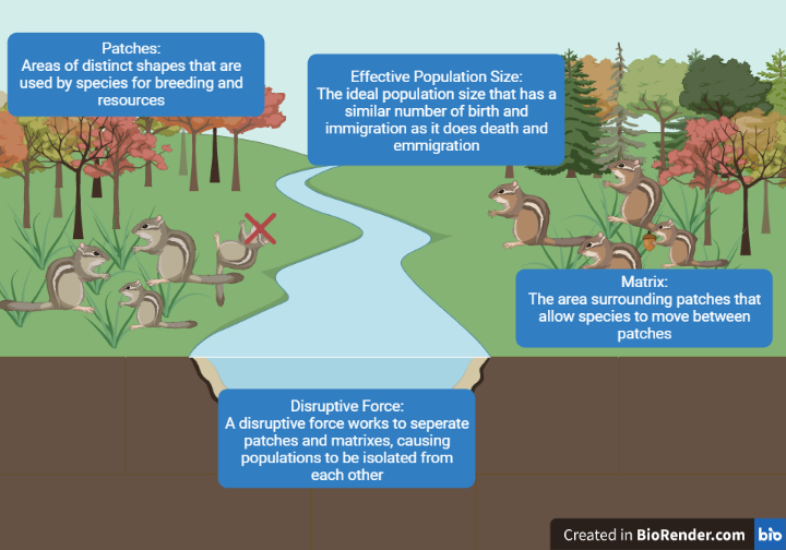
- Metapopulations: a set of local populations occupying habitat patches, connected to one another by the movement of individuals
- Natural Disturbances: disruptions to landscapes caused by fire, flooding, earthquakes, etc.
- Patches: areas of habitat suitable for a species of interest
- Spatial heterogeneity: different spatial patterns of the elements that make up the landscape, and the processes that give rise to those patterns
Outline of Notes:
Every landscape has features that make them unique and appealing to different plants and animals. Areas of habitat can be divided into patches, matrices, edges, and corridors. The proportion of each of these components can determine which types of species inhabit the area.
Anatomy of a Fragmented Landscape:
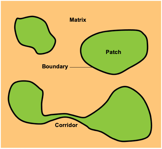
- Patch: habitat that is suitable for a specific species of interest, and separated from other habitats via boundaries.
- Characteristics of distinct patch types:
- Different land type
- Species composition
- Succession
- Differing levels of disturbance
- Based on the size of study organism
- Characteristics of distinct patch types:
-
- Larger patches have larger core areas
- Core Areas: the interior of a patch where resources are more abundant
- Matrix: considered the ‘background’ ecological system that has a high degree of connectivity, compared to the patches within it.
- Boundary or Edge: the perimeter of patches. The edge makes up its own habitat, as well as the border of a patch.
- Corridor: a connection between patches that allows individuals to pass through a matrix; not always a permanent fixture in the landscape
Question from a Student:
“Does a patch have to be undisturbed? I know some species, especially some types of (invasive) plants, thrive in areas of high disturbance, so wouldn’t a patch for these species be a highly disturbed area?”
Answer: Great question! Disturbance is one characteristic that can vary across a landscape. Many species have adapted to (and even depend on) some level of disturbance. (Consider, for example, trees whose seeds require fire to germinate.)
Remember, also, that suitability is context dependent (i.e., specific to a particular species). A given area might be patchy for certain organisms that cannot survive and reproduce outside of boundaries, but not patchy for others that can function in matrixes (such as birds adapted to cities).
Habitat Patches:
- Patchiness: a way of describing the availability, size, and connectivity of a suitable habitat within a given landscape
- Causes of Patchiness:
-
- Climate: locations with specific climatic conditions can cause a patch, like an oasis in a desert, or the desert itself.
- Geology: Mountains, valleys, and other geological boundaries
- Topography: Any topographical boundary created by a body of water: rivers, streams, lakes, or oceans
- Disturbance (natural or anthropogenic):
-
-
- Natural disasters (ex: wildfires, hurricanes)
- Human behaviors and our infrastructure is perhaps the most common creator of patches:
- Roads can create impassable boundaries for most creatures
- We create patches of habitat (parks and gardens) in otherwise unsuitable urban areas
-
- Desirability of patches depends upon:
- Resource concentration
- Species diversity
- Number of available niches
- Climate patterns
- Ground cover
- Size of the patch and/or amount of edge
- Anthropogenic effects
Boundaries and Edge Habitats:
- Boundaries can vary significantly in length, width, height, and porosity (how easily species can pass through)
- They allow for the transfer of material, energy, and organisms between patches
- Some boundaries may restrict or facilitate dispersal, depending on the conditions and species
- They can be abrupt distinct places where the landscape changes, or transition slowly over the landscape forming
ecotones- Ecotone: A broad transition zone between adjoining patches
- A diversity of environmental conditions may support the colonization of new plant and animal species
- Effects of habitat fragmentation:
- Edge habitat increases while interior habitat decreases
- Edge species increase while interior species decrease

- Species that live in edge habitat may be:
- Animals whose requirements vary with…
- Age, sex, required resources, or ideal habitat type
- Or plants that can tolerate:
- High light levels, dry conditions, or high temperatures
- Species that are favored by disturbance, such as:
- Invasives, pioneers, r-strategists, or generalists
- Animals whose requirements vary with…
A Case Study in Corridors: Dr. Nick Haddad’s Work [1]
- Dr. Haddad studied corridors and how they influence the dispersal of common buckeye butterflies (Junonia coenia) in South Carolina.

Figure 4. A graphic showing the research area of the common buckeye dispersal study in South Carolina.
- The researchers measured movement from a central, one-hectare patch to four surrounding patches that varied in connectivity and shape:
- One patch was completely connected to the central patch
- Two patches had wings extending from their sides
- One patch was rectangular with no connection to the central patch
Result:
The common buckeye was 3-4 times more likely to move from the center patch to the connected patches than to the unconnected patches.
Question from a Student:
“I am interested in what a corridor would be like in a natural setting, and what it might look like?”
Answer: Great question! The concept of a corridor came about primarily because of human-caused fragmentation. However, a natural corridor could be a fallen log across a stream or river that acts as a natural bridge. Here’s a video where somebody put a camera in front of one such log and recorded days and days’ worth of footage to see what animals used it. Turns out, there were a lot (even a black bear)!!
Metapopulation Dynamics:
- As habitats become fragmented, metapopulations are formed
- Metapopulations: A set of local populations occupying habitat patches, connected to one another by the movement of individuals
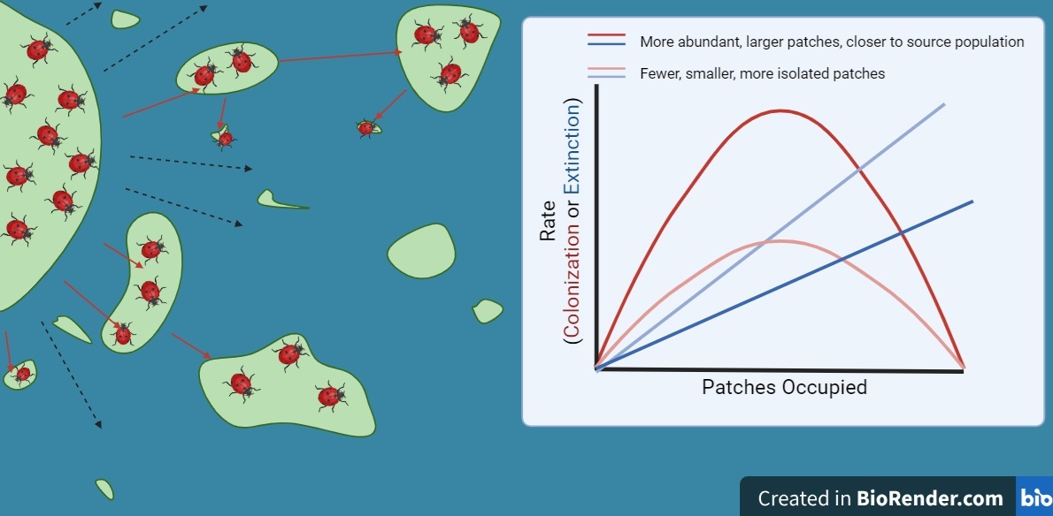
- As patch size increases, rates of extinction decrease
- As patches become more isolated, rates of colonization decrease as it becomes more difficult for individuals to disperse.
- Changes in rates of extinction and colonization affect the proportion of occupied patches
Key Takeaways
Overarching Themes and Unifying Concepts:
- Patches are contextual, as is everything in ecology.
- Suitability of patches is dependent on a variety of factors including the physiological requirements of an organism, life history traits, the size of the organism being studied, and the trophic level of the focal organism.
- All landscapes are a mosaic of many suitable patches and non-suitable matrices that can be constantly changing depending on different types of disturbances.
- Patch size and isolation influence metapopulation dynamics.
- Different patches offer different types of resources and habitat types, thus allowing for a wide variety of different species and niches.
Unsolved Mysteries and Future Research:
- There has been some disagreement in the literature on the effect that corridors have on population dynamics. However, the general thoughts surrounding them are: all species utilize and benefit from corridors, including both natives and invasives [3] Which poses the question of whether they are truly helpful in each context. It has also been indicated by some researchers that there has not been enough research on corridors in general. We suggest that more research be performed on corridors to ensure whether or not they are beneficial to wildlife.
Blog Style Summary:
What do butterflies, coconuts, and salamanders have in common? They are all metapopulations that have been separated as a result of landscape ecology.
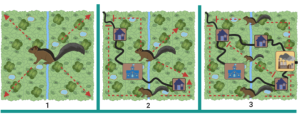
When someone talks to you about a metapopulation you probably think of a massive population of species. You are right to an extent: If a population is a collection of individuals belonging to the same species, then a population of populations would be a collection of populations across a landscape. Metapopulations usually use different habitat patches that are connected by corridors. That’s where landscape ecology comes into play. Landscape ecology is the study of the composition, structure, and function of the landscape. According to the article by Howell et al. (2018), landscape ecology is “understanding how spatial structure influences ecological processes”. Natural disturbances, such as floods, are one way in which spatial structures are changed and metapopulations are formed.
Floods are a frequent occurrence across the coastal plains of North Carolina, the native range of the Eastern tiger salamander (Ambystoma tigrinum) (Figure 1.). If a flash flood isolated a portion of the salamander population, it would become a metapopulation. Once the flood waters begin to recede, corridors form between the metapopulations. This facilitates travel between the metapopulations that were previously isolated, enabling them to interbreed. These corridors connect suitable niches or “patches” where the salamanders have access to adequate resources. The movement of organisms from one patch to another is known as dispersal.
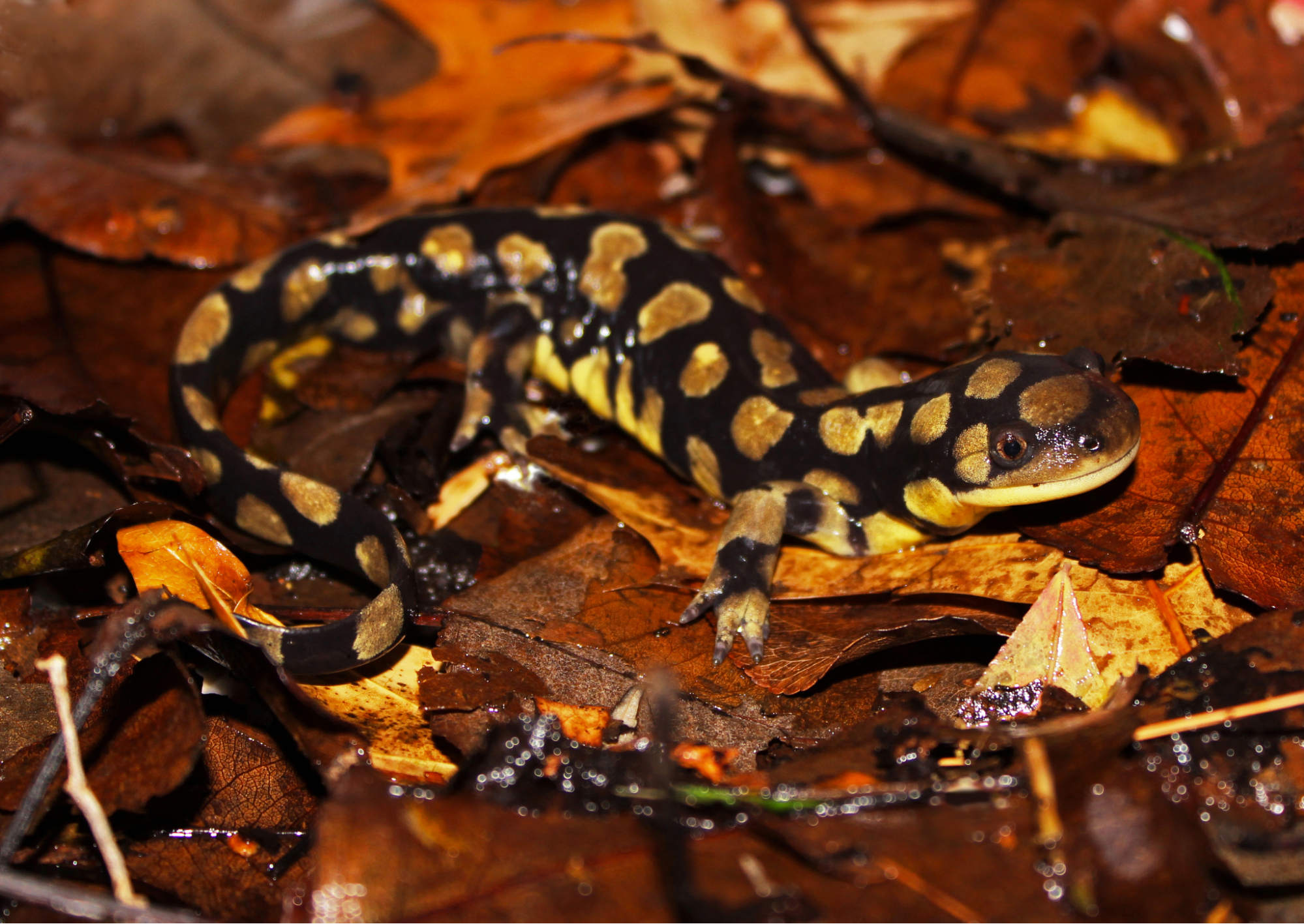
So what exactly does a ‘patch’ look like? A patch of suitable habitat for one organism might not be a patch for another. In the case of the salamanders, their patches are coastal plains surrounded by water (the matrix). This might not be desirable for other organisms, like birds, who might require forested areas for nesting and foraging. Patches are defined by their boundaries, which are surrounded by the matrix. Boundaries (or edges) come in all different shapes and sizes. They can be very narrow and have sharp transitions between different habitat types, or they can be wide and gradually change between habitat types, providing a “buffer zone” or ecotone – like riparian zones along bodies of water., or the transition from ocean to maritime forest on barrier islands. Boundary (or edge) habitats increase in highly disturbed zones, and because of this, they favor organisms that can tolerate a wide range of environmental conditions.
The eastern tiger salamander might be considered an edge species, due to its semi-aquatic lifestyle. It can live on the edge of a body of water and strip of land, whereas other species, called interior species, require large, uninterrupted areas of interior habitat and cannot survive well in edge habitats.
Interior species are highly susceptible to habitat loss and fragmentation. This is because patches have to achieve a certain minimum size before interior habitat can form, whereas edge occurs anywhere there is a border. The Florida black bear is an interior species that has had much of its suitable habitat reduced due to human expansion. This species was once abundant in the southeastern United States, but now has only a few populations scattered across much smaller, fragmented, and isolated patches. Scientists are now making efforts to create effective corridors for this species, which is an example of how metapopulation dynamics can be used to promote conservation (Dixon et al., 2006).
You might be asking what’s the difference between metapopulations and landscape ecology, as it sounds like they go hand in hand. However, metapopulation ecology models tell you how the spatial distribution of the patches affects colonization and extinction, whereas landscape ecology models use detailed descriptions of landscape structures (Howell et al. 2018).
To summarize, metapopulations are small populations that have been separated from the original population by landscape ecology. The spatial distribution of the metapopulations within a matrix are dependent on patches and dispersal patterns. Some species prefer using corridors to transit between patches, while others don’t care which patch they’re in. Different species can be characterized by the patches they inhabit and can be referred to as either ‘edge-species’ or ‘interior species.’ The topic of metapopulations and landscape ecology is an important one for conservation efforts as humans continue to urbanize land and fragment natural habitats.
Spotlight on NC:
Red Wolves: Restoring a Species
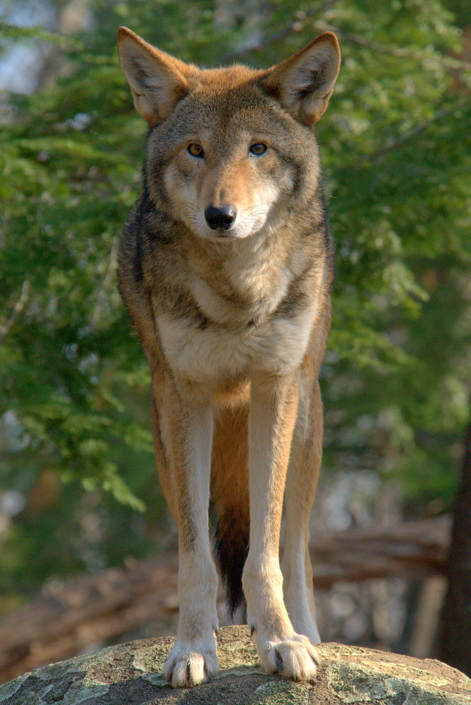
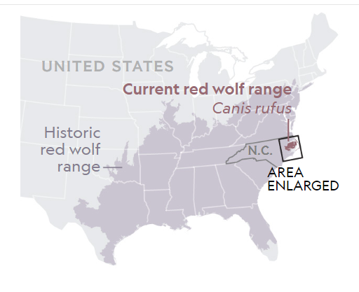
Red wolves (Canis rufus) are wolves that were once found across the Southeastern United States. About 4 feet long, they have reddish coats with gray and black highlights and a black tail. Smaller than gray wolves and larger than coyotes, 400 wild red wolves existed in 1970 before they became functionally extinct in the 1980s. Reintroduced red wolves are the world’s most endangered canid with a range spanning the Albemarle Peninsula of North Carolina, a minuscule fraction of their historical range. Historically, red wolves roamed across the southeast, from central Texas to Florida and as far north as New York [1].
The drastic decline of this species is due to the fragmentation of their natural woodland habitats, which has separated populations and limited dispersal. Like gray wolves, they form packs based on family relationships and defend their 20-80 mi2 territory from other canids. Unlike gray wolves, their packs are much smaller and consist of a mated pair and their 5-6 pups [1]. Due to the lack of suitable habitats, the ecological density of red wolves has suffered a steep decline, causing a lack of survivorship of the species.
Predator-prey interactions have become disrupted due to human interference, as humans shoot the wolves to protect their livestock and game, further contributing to their decline [1]. The remaining red wolves have struggled to maintain a healthy population density, forcing them to change their mating behaviors and hybridize with coyotes and gray wolves (https://doi.org/10.1111/conl.12157).
Efforts to recover the red wolf population are headed by the U.S. Fish and Wildlife Service through the Red Wolf Recovery Program (RWRP). In the fall of 2020, a court order mandated that eight red wolves be released into the wild. The Southern Environmental Law Center (SELC) believed that this low number of red wolves being released was in violation of the Endangered Species Act and sued the U.S. Fish and Wildlife Service for their lack of action [2]. In July of 2021, the RWRP was updated for the first time in thirty-one years. The new plan consists of a species status assessment, a recovery plan, and a recovery implementation strategy [3]. The Red Wolf Recovery Program has paved the way for successful captive breeding and reintroduction initiatives beyond just red wolves. Recovery programs for other endangered species have implemented tactics first used for the red wolves. The RWRP pays close attention to managing genetic diversity amongst the growing captive population by rotating the captive wolves across the different facilities [3]. It is important that the captive breeding can be representative of a diverse population to ensure that the red wolves can actually survive environmental shifts and challenges once reintroduced into their natural habitats. The program also aims to limit interactions between handlers and wolves in captivity to promote a healthy and natural pack structure and help deter the wolves from approaching humans after release.
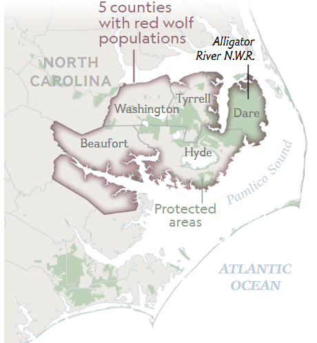
Currently, the Red Wolf Recovery Program utilizes radio collars on adult wolves to track movement and overall population changes of red wolves in their only known wild habitat. This known population is spread over five NC counties of the Albemarle Peninsula [3]. The peninsula is a compilation of many patches that range from small to large in size. The largest patch is the Alligator River National Wildlife Refuge in Dare County. The refuge has a fragmented corridor that spans through Hyde and Tyrell County into the Pocosin Lakes National Wildlife Refuge. This area was chosen because of the low abundance of coyotes in the area and low human population relative to the rest of NC. Choosing an area with a low human population was crucial to minimize interactions between the wolves, humans, and livestock. Per the 10(j) experimental population classification assigned to the wolves in 1995, they cannot be removed from the area unless it is first demonstrated that the wolf is a threat to human, livestock, or pet safety [1].
While the Albemarle may seem like a perfect habitat, the peninsula is surrounded by the Albemarle and Pamlico Sounds and many small water inlets cutting into the land. This type of landscape ecology could decrease overall connectivity and have a negative impact on the potential for the red wolf population to thrive. Furthermore, the three main patches that contain the wolf population are separated and do not have fully connected corridors to allow for gene flow. This adds to the growing concern of roaming red wolves finding their way into human-inhabited areas that have expanded since the recovery program started. However, the wolves have come a long way since their reintroduction. If we want to continue their progress, then wildlife corridors will be crucial to their survival.
The Red Wolf Restoration program is nationally renowned as a model for metapopulation ecology. The few patches that cover the Albemarle Peninsula are a model for future endangered species recovery programs. Right now, captive wolf populations are rotated throughout the enlisted conservation facilities where they are heavily managed, but future recovery efforts will aim to limit human interaction. Going forward, the Red Wolf Recovery Program will continue to monitor and advocate for the protection of the red wolf population.
Live Red Wolf Webcam:
https://nywolf.org/meet-our-wolves/webcams/webcam-red-wolves-charlotte-jack-family/

How to Apply Ecology in a Changing World
Increasing Connections within Metapopulations
Have you ever thought about how much time you spend in each area of your residence? Do you spend as much time in your supply closet as you do in the kitchen? Probably not, and wildlife exhibit similar behaviors. Core areas are habitats that are used disproportionately more often compared to other, more available habitat, because they offer some benefit (food source, water hole, or good cover). Looking at these core areas and the value each serves, you can see how resources are spread out across a landscape, this is referred to as spatial heterogeneity. If you monitor landscape use, you will realize that some areas are used by more individuals than other areas. This can be compared to the number of customers who choose to go to a popular McDonalds, versus an overpriced burger place down the street. The McDonalds is going to get more use, similar to how a patch of forest with ample hard mast production would host higher populations of deer.
The people at McDonalds would be considered the population at that given location and time. All the populations of customers at all McDonalds in an area make up a metapopulation. Likewise, all of the suitable patches that deer can potentially live in, make up the metapopulation of deer in an area. These different populations within a metapopulation live in different areas with different environmental conditions. Remember that these populations aren’t isolated, and movement between these populations is important for continued gene flow and to prevent inbreeding. This is where corridors come in. Corridors are used by species to commute between areas or populations, just like the hallway that connects your kitchen and bedroom.
Urbanization and human disturbances cause fragmentation of ecosystems around the world. Natural disasters can also cause fragmentation, but humans are the predominant driver of fragmentation today. Doing so creates patches. A patch is a relatively suitable habitat for native species to flourish, surrounded by matrix. Matrix is the surrounding habitat that is not suitable for focal species to travel through or reproduce. Fragmentation has many negative effects on species. Compared to larger or better connected populations, isolated populations may exhibit decreased genetic diversity, which limits their ability to adapt to environmental change. Disease and parasitism may also spread rapidly across smaller patches and more fragmented habitats. Fragmentation also increases the proportion of edge to interior habitat, rendering small patches unsuitable for specialists that require interior habitats. Compared to the interior, the edge/boundary of a patch is typically warmer, lighter and drier due to its lack of large vegetation and closer proximity to (human) disturbances. While generalists and invasive species tend to be favored by disturbance, these species can degrade the interior habitat and limit the resources available to native species.
The shape of a patch affects the amount of edge versus interior area, which in turn affects biodiversity and the presence of specialists. Corridors can facilitate gene flow from surrounding patches, increasing overall genetic diversity across subpopulations. (Resasco et. al 2014) In some cases, corridors can allow invasive species to spread into surrounding patches; but corridors also enable many native species to move to other patches that may provide a better core area or resources.
Anthropogenic wildlife corridors are a possible solution to habitat fragmentation. Corridors have provided improved mobility between patches that were once separated, and can increase genetic diversity among populations. Combined with other management efforts, corridors can also reduce harmful human-wildlife interactions such as attacks and car crashes. One example of this is the Snoqualmie Pass East Project. This project (timeline 2009-2029) aims to provide safe wildlife passage across a 15 mile stretch of interstate highway I-90 through Washington. One of the main parts of this project are two large overpasses above the highway – the largest wildlife overcrossings in North America.

These overpasses and other structures have helped reconnect the north and south cascades of Washington. This is incredibly important for many wildlife species. Through dedicated monitoring efforts, thousands of animals have been seen using these structures as safe crossings. It even enabled a moose to travel hundreds of miles away from its former home range! These structures provide opportunities for wildlife to increase their range and find suitable habitats that were previously impossible or extremely dangerous to get to.
The way we use space is vitally important to us in our day-to-day life – yet, it’s easy to forget that the plants and animals around us require just as vital use of different spaces as we do. Sadly, humans often disrupt and even destroy habitats that are important for wildlife. As the primary driver of habitat fragmentation, it is our ethical responsibility to limit its negative effects. Land use mismanagement can lead to increased competition and species extirpation as well as declines in soil quality and food abundance resulting from a lack of insect pest predators. Fortunately, there are many ways to combat this. One of the most promising is the installation of wildlife corridors. The use of wooded overpasses, greenways, community native planting initiatives and other formats can significantly limit the effects of fragmentation. Some invasive species may persist or thrive for a time; but the positive effect on native plants and animals, as well as humans, is incredible. When corridors are implemented, species gain access to more resources and maintain higher genetic diversity, both of which are positively associated with population growth and persistence. Humans have a greater ability to change the world around us than ever before; and with deliberate data-informed management, planning, and design, we might just be able to have our cities and wildlife too.
Sources:
Resasco, J., Haddad, N. M., Orrock, J. L., Shoemaker, D., Brudvig, L. A., Damschen, E. I., … & Levey, D. J. (2014). Landscape corridors can increase invasion by an exotic species and reduce diversity of native species. Ecology, 95(8), 2033-2039. https://doi.org/10.1890/14-0169.1
“First wildlife bridge coming soon to Snoqualmie Pass” by nordique is licensed under CC BY 2.0. To view a copy of this license, visit https://creativecommons.org/licenses/by/2.0/?ref=openverse.
I-90 Wildlife Corridor Campaign: Conservation Northwest. Conservation Northwest . (2022, April 1). https://conservationnw.org/our-work/habitat/i-90/
Wildlife Habitat Connectivity – Snoqualmie Pass East Project. WSDOT. (2022). https://wsdot.wa.gov/about/data/gray-notebook/gnbhome/environment/wildlifehabitatconnectivity/snoqualmiepasseastproject.htm
Featured Ecologists:
David Eggleston, Phd
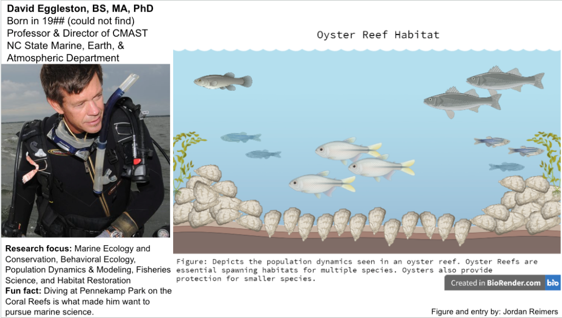
Dr. David Eggleston’s research focuses on testing, refining, and applying general ecological concepts to marine systems. The goal of his research is to improve the understanding of ecological processes in marine ecosystems and to apply them to sustainable management techniques. In order to achieve this understanding, he conducts field observations, experiments, computer simulation modeling, and geochemical and molecular tools. Eggleston researches metapopulations, species interactions, and community ecology. His most recently published article in 2021 is titled Metapopulation dynamics of oysters: sources, sinks, and implications of conservation and restoration. A few of the findings of this article include the decline of oyster populations, reef-specific population trajectories that are dependent on spatiotemporal variation for larval recruitment, inter-reef larval connectivity on metapopulation dynamics are more important than the local larval retention process, and that spatiotemporal variation in the source-sink status of subpopulations. This research reaffirmed that oyster reefs need to be continually protected and managed. This research is important for understanding how to best conserve marine ecosystems, particularly in the context of warming ocean temperatures due to climate change.
Mona Papeş, PhD
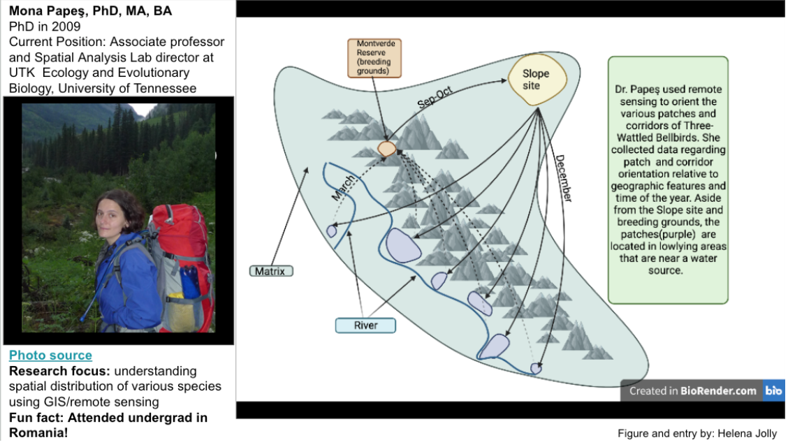
Dr. Mona Papeş uses remote sensing and GIS data in order to understand the anthropogenic effects on the environment, and consequently the effects on the species distributions. In her research, her hope is to apply local-scale environmental predictors to broad-scale estimations of biodiversity. She uses niche modeling to predict future species distributions and niches. Papeş studies a broad range of species in order to better understand and model population distributions. She examines concepts such as species distribution and understanding species’ niches in relation to the geographical distribution of the ecosystem. She uses remote sensing as well as GIS in order to model her findings. Her dissertation focused on the applications of remote sensing in neotropical rainforests, through the examination of frugivore species and the characteristics of the fruit trees that act as resources for them. She found that tree spectra varied temporally, and her research indicated that it is possible to study trees through remote sensing. In her research, she has found that regardless of what climate change scenario, it is likely that species distributions are estimated to shift. Through her research, she is able to better understand seasonal variation in species distribution. The implications of her research allow others to gain insight into species biodiversity and niche resiliency to anthropogenic effects, allowing others to formulate more beneficial conservation and mitigation strategies.
Eric Romaniszyn

The research conducted explores Podostemum ceratophyllum in the Little Tennessee river and the effects on benthic macroinvertebrates abundance, biomass, community composition, functional feeding and group structure. The study used three different treatments in two different outcrops over a span of six weeks of data collected. Their research looks at how the plant influences the macroinvertebrates population dynamics and more specifically the use of the plant as habitat and resources. The plant acts as a landscape patch for the macroinvertebrates to live, eat, reproduce, and shelter. The findings indicate that the plant does have a positive relationship with the biomass, group structure and abundance; feeding and community composition, was not a significant finding. The importance of the research illustrates how having healthy patches for macroinvertebrates to inhabit influences the population density. In headwater streams of the Southern Appalachian Mountains the presence and health of the macroinvertebrates are an indicator of the stream health and water quality. The water from this area is super sensitive and important to maintain for the ecosystem and all of the sensitive organisms that need to live here. It is a major conservation effort to keep the water from the river clean and all of the amazing wildlife that lives here.
Monica G Turner

Dr. Monica Turner studies how spatial heterogeneity and disturbance affects ecosystems and landscape ecology. Her past research has focused on studying coniferous forest regrowth after wildfires and understanding how to adjust management strategies to better adapt to these occurrences as well as to climate change. My biorender in this slide covers her research on how reducing fire severity can act as another buffer against slower forest regrowth which is caused by climate change. In the top panel is a forest receiving “typical” prescribed fire treatment resulting in slower tree growth. Whereas the bottom panel shows how reducing prescribed burn treatments can cause less damage and increase forest regrowth further reducing impacts from climate change, such as dryness.
Frank Van Manen, Phd
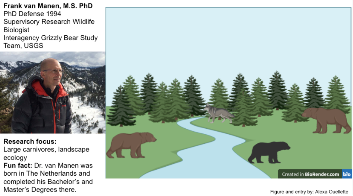
Since 2006, Dr. van Manen has focused his research on the grizzly bears of Yellowstone National Park. His work has been essential in the classification of these species as endangered and retaining their federal/state protection. Recently Dr. van Manen has also been looking at how the bear populations (both brown and black) interact with the gray wolves of the park and how the species are coexisting and affecting each other. Prior to working with the grizzly bears, Dr. van Manen worked on research teams that worked to conserve and protect giant pandas in China, as well as sloth bears in Sri Lanka and Andean (spectacled) bears in the Andes Mountains. Dr. van Manen also worked with American black bears during his time at the University of Tennessee-Knoxville, where he further explored his interest in how landscape ecology can affect populations and vice versa.
Student contributors:
Note Outline: Cheyana Bassham, Leo Kerner, Alexa Ouellette, Claire Waters, Robert Whiting
Blog Style Summary: Malia Naumchik, Sydney Kuczenski, Dustin Bigford, Dawson Bigford
Spotlight on NC: Shomari Presswood, Sarah Rachita, Chip Ralph, Breana Lavallee
Featured Ecologists: Jordan Reimers, Helena Jolly, Alexa Ouellette
How to Apply Ecology in a Changing World: Beka Helms, Marley Kelly, Ian Thomas, Reece Neiderer
a set of local populations occupying habitat patches, connected to one another by the movement of individuals
study of the composition, structure, and function of the landscape
a narrow strip of habitat that connects two patches
the edge or perimeter of a patch
the surrounding landscape in which patches of suitable habitat are embedded
a broad transition zone between adjoining patches
areas of habitat suitable for a species of interest
